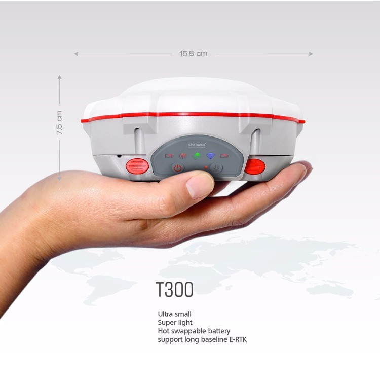
T300 GNSS ComNav
Roll over image to zoom in
$ 66.56
With decades of experience in the surveying GNSS receiver, the T300 is a product which combines lots of market proved advantages together. It can track all the working GNSS constellations. By using ComNav’s unique QUANTM algorithm technology, it can function in RTK mode with all the GNSS constellations or by using any single GNSS constellation such as GLONASS or BeiDou. The strong anti-interference ability of the receiver makes it possible to work in any environment. Ultra Small ·Super light ·Many user-friendly conveniences built in ·GPS L1/L2/L5, BeiDou B1/B2/B3, GLONASS L1/L2, Galileo E1, E5a, E5b ·Low power consumption ·Support long base line E-RTK Signal Tracking Channels 256 channels with simultaneously tracked satellite signals GPS L1 C/A, L1C, L2 P, L5 BeiDou B1, B2, B3 GLONASS L1, L2 Galileo E1, E5a, E5b SBAS WAAS, EGNOS, MSAS,GAGAN Performance Specifications Cold start <50s Warm start <30s Hot start <15s Initialization time 10s Signal re-acquisition <2s Initialization reliability Typically>99.9% Positioning Specifications Static and Fast Static Horizontal: 2.5 mm 0.5 ppm RMS Vertical: 5 mm 0.5 ppm RMS Horizontal: 3mm 0.1 ppm RMS Vertical: 3.5mm 0.4 ppm RMS Real Time Kinematic Horizontal: 8 mm 1 ppm RMS Vertical: 15 mm 1 ppm RMS E-RTK (<100km) Horizontal: 0.2 m 1 ppm RMS Vertical: 0.4 m 1 ppm RMS Code differential GNSS positioning Horizontal: 0.25 m 1 ppm RMS Vertical: 0.5 m 1 ppm RMS SBAS Typically < 1 m 3D RMS Standalone <1.5 m 3D RMS Communications Communication port 1 x 7 pin lemo port (Combined Serial and USB function) Baud rates up to 921600bps for serial Radio modem 4G modem Tx/Rx with full frequency range from 410-470MHz Transmit power: 0.5-2W adjustable Range: 1-5km - 4G Bands: 800/900/1800/2100/2600 MHz - 3G Bands: 900/2100 MHz - 2G Bands: 900/1800 MHz - Support GSM, Point to Point/Points and Ntrip Positioning data outputs 1HZ, 2HZ, 5HZ, 10HZ, 20HZ Indicating light 5 LEDs (indicating Power, Satellite Tracking, Differential data, GPRS and Data Recording) Bluetooth® V 4.X protocol, work compatible with Windows 7, Windows mobile and Android Data Format Data inputs/outputs Correction data I/O: RTCM2.x, 3.x,CMR(GPS only), CMR (GPS only) Position data outputs ASCII: NMEA-0183 GSV, RMC, HDT, VHD, GGA, GSA, ZDA, VTG, GST, PJK, PTNL ComNav Binary update to 20Hz Physical Size(W×H) 15.8cm×7.5cm Weight 0.95kg(include battery) Environmental Operating temperature -40 °C to 65 °C (-40°F to 149°F) Storage temperature -40 °C to 85°C (-40°F to 185°F) Humidity 100% condensation Waterproof and dust proof IP67 protected from temporary immersion to depth of 1 meter, floats Shock Survives a 2-meter drop on to concrete Electrical Input Voltage 5-27 VDC Power consumption 3.1 W Li-ion battery capacity 2x2000 mAh, Up to 10 hours typically Memory 8 GB internal memory (16 GB and 32 GB is optional) Software CGSurvey Survey Master ComNav’s field data collection software CGSurvey SurvCE (optional) Carlson’s SurvCE field data collection software FieldGenius (optional) MicroSurvey’s FieldGenius field data collection software Note: ComNav will remove the radio modem according to different country’s regulations.